[edit]4.1. Defining cropping practices and conditions and preparation of polygons for main crop growing areas in the country.
Peter Hoefsloot
In order to do any meaningful crop forecasting, localized crop conditions should be take into consideration. First of all, some characteristics on crops related to local practices will be recorded. Subsequently, it needs to be clarified where the staple crops are grown. The crop growing areas are digitized for use with the CM Box software.[edit]Gathering crop information
The FAO Water Balance model is using the following crop information:
- Planting dates. Planting dates occur rarely on the same dekad every year. However, in most circumstances it is possible to establish a “window of opportunity” for planting lasting 1 to 3 months. As an example, this window of opportunity for maize is October – December in large parts of Southern Africa. AgrometShell contains two functions to estimate planting dates from weather data. One functions is based on a rainfall threshold, the second function is based on the rangeland index.
- Cycle lengths in dekads. Every crop variety has its own cycle length. Usually in arid areas, crop lengths are shorter than in wetter areas.
- Water Holding Capacity. This is the maximum amount of soil water available to the crop within root range (in mm). Methods have been developed to estimate the Water Holding Capacity from the FAO soil map.
- Crop Coefficients. Crop coefficients can be set with the AgrometShell Database-Configure-Crop Coefficients function. Crop coefficients are localized, but more or less “constant” for large areas like the Sahel, or Eastern Africa.
- Irrigation. The water balance calculations are can take irrigation into account. If irrigation will be applied it needs to be clear how much. Possibilities are : a fixed amount in mm per dekad, different amounts for different dekads and an automatic amount of irrigation that prevents water stress.
[edit]Preparation of polygons for main crop growing areas
The establishment of cropping zones for the most important staple crops helps to:
- Select stations for the water balance calculations. It is of little use to calculate a water balance for areas were crops are absent.
- Blank out irrelevant areas in output maps and images.
In the following example a map will be created in right format (Bna) of the millet growing area in India.
USDA / NOAA has created a simple picture that roughly denotes millet growing areas in India. This picture will be digitized for use with the CM Box software 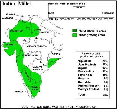
Digitizing can be done by hand, but it is far more convenient to use software programs like Windisp. In this example, a vector map of India is loaded into Windisp to be displayed in the background, using the File-Open-Map function. This will facilitate digitization. 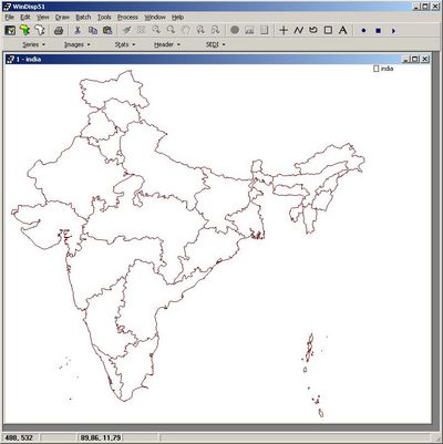
A new polygon will be digitized onto this map with the Draw-Map-Region function. The name of the boundary file will be millet.bna. The line color and thickness is set such, that easy digitizing is accomplished. 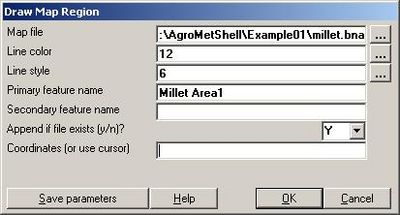
The first millet growing area is now digitized. After all millet growing areas have been finished the boundary file millet.bna is completed. 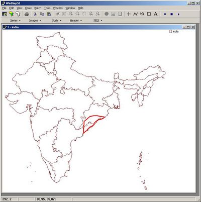
Far more advanced software is available for digitizing maps. Even automatic digitization from bitmaps is possible. A very good freeware digitizing application called Wintopo, can be downloaded here: http://www.softsoft.net/wintopo/dl-wintopo.htm

| CM Box User Guide | Main Page | About | Special pages | Log in |
Printable version | Disclaimer | Privacy policy |


